Sentinel-3C satellite images show heat contrast between Morocco and Spain
The European Space Agency (ESA) has just unveiled the first thermal images from its Sentinel-3C satellite. Morocco appears in the images, with temperatures above 30 °C in some regions, contrasting with those recorded in southern Spain.
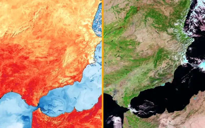
The images published on Wednesday, November 18 were captured on November 2. They show Morocco, Algeria, the Iberian Peninsula and part of France. According to the ESA, temperatures in some areas of Morocco exceed 30 °C on the thermal map, compared with around 25 to 30 °C in Andalusia and southern Portugal.
On Bladi.net : Morocco’s mysterious red patch visible from space reveals thriving desert agriculture
These measurements are known as “brightness temperatures” and are calculated from infrared radiation captured at the top of the atmosphere. They differ from air temperatures recorded by weather stations.
A second image, produced in false color, reveals contrasts between the landscapes. Areas of dense vegetation appear bright green and generally correspond to the coolest surfaces on the thermal map. The sensors also make it possible to observe temperature differences between land and the waters of the Atlantic and Mediterranean.
On Bladi.net : Morocco: Satellite images reveal a country transformed by record rainfall
Launched on September 15, 2026, Sentinel-3C carries a radiometer capable of observing land and sea surfaces in nine spectral bands. Two additional channels are dedicated to detecting and tracking fires. These first thermal images confirm that the instrument is working properly, while it is still in the commissioning phase.