Winter Rains Transform Moroccan Landscape, NASA Satellite Images Show
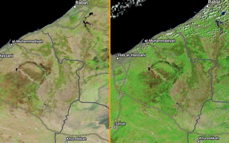
The Moroccan landscape between Rabat and Settat has apparently changed in a matter of weeks. NASA satellite images dated February 14 and March 26, 2025 confirm this: the vegetation has experienced a clear recovery, a direct consequence of the winter rains that fell during this period.
While the February 14 image showed soils with ochre and brown hues, signs of drought due to low winter rainfall, the March 26 image reveals a generalization of green. This color shows a rehydration of the land and a resurgence of plant activity. The phenomenon is particularly pronounced on the plateaus and in the agricultural plains, where the plant cover has become denser.
These observations come from the high-resolution optical sensors on board NASA satellites dedicated to Earth observation and climate monitoring. The analysis of spectral reflectance - the way the soil and plants reflect light - makes it possible to assess the evolution of biomass and soil moisture levels.
Related Articles
-

Border Police Crack Down on Thriving Stolen Car Trade to Morocco
1 September 2025
-

Vacation Nightmare: Dutch Teen’s Seizure at Moroccan Airport Leads to Harrowing Medical Ordeal
31 August 2025
-

Morocco’s Intelligence Services: The Unsung Heroes in Global Counter-Terrorism and Drug Busts
31 August 2025
-

Mental Health Crisis Grips Morocco: 425 Cases Spark Calls for Urgent National Action
31 August 2025
-

Vueling Expands Winter Routes: Barcelona to Morocco, Slovenia, and France
31 August 2025