NASA Satellite Captures Stunning Infrared Image of Morocco’s Ancient Anti-Atlas Mountains
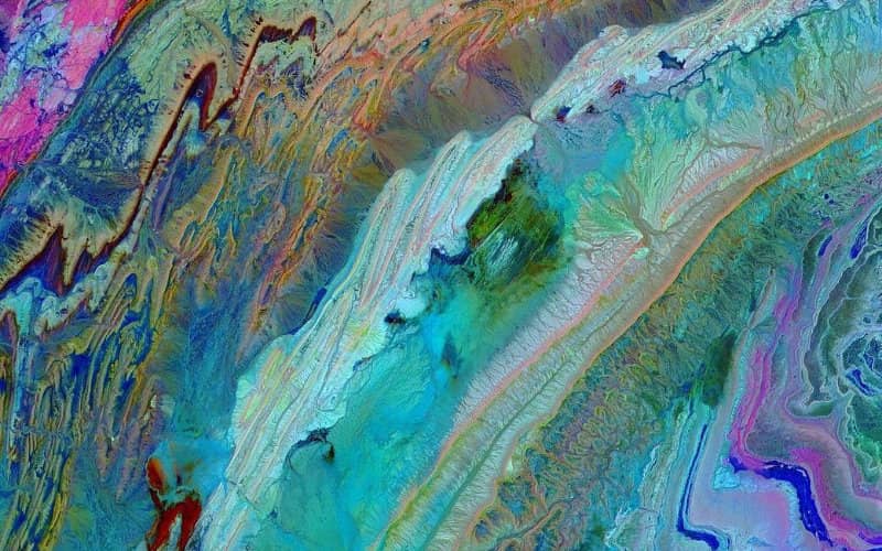
The American space agency NASA published this Friday on its Instagram account a colorful satellite image that arouses curiosity and elicits admiration from Internet users. This shot, taken at the level of the Anti-Atlas mountains, located in the southwest of Morocco, has already collected more than 540,000 likes since its publication.
In a post accompanying the image, NASA invites you to take "a colorful journey about 708 km above the Earth’s surface via an orbiting satellite". "In this stunning image of southwestern Morocco, we see the magnificent Anti-Atlas mountains that formed as a result of the collision of the African and Eurasian tectonic plates about 80 million years ago," the American space agency explains in its description.
Continuing its explanations, NASA argues that "the photo was taken in infrared light - invisible to the naked eye - to highlight the different layers of rocks and sediments, giving a tie-dye effect".
This shot, which is not recent, was taken on November 5, 2007 by the ASTER instrument on the Terra satellite, the first satellite to form the Earth Observation System (EOS) at its launch in 1999, it is announced.
Related Articles
-

Morocco’s New Tax Rules Shake Up Rental Income for Expat Landlords
27 July 2025
-

Tangier Ordered to Pay Millions After Turning French-Owned Land into Cemetery
27 July 2025
-

Food Poisoning Strikes Moroccan Wedding: 11 Family Members Hospitalized After Chicken Dish
26 July 2025
-

UK Warns Travelers: Morocco’s Airports Crack Down on Drug Smuggling with Severe Penalties
26 July 2025
-

Moroccan Expats’ Property Transfers: Tax Breaks for Family Donations Unveiled
26 July 2025